|
|||
|
|
Chapter 2 THE SOCIAL AREAS OF CINCINNATI
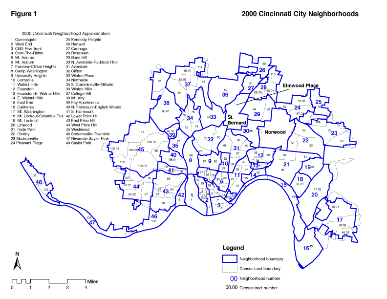
The Four Social Areas Described One of the major purposes of this report is to take the great mass of 2000 census data and make it more useful for the purpose of analyzing the needs of various sections of the city.
In Chapter 1 we have described the process whereby the census tracts were ranked according to a complex index of social class and then grouped into four quartiles. Appendix II gives us the actual census tracts and their index numbers. The neighborhoods, their census tracts and overall SES index are shown in Table 2a. The quartiles or social areas themselves can be used as units of analysis, along with census tracts and neighborhoods.
Table 2b shows the summary statistics for the four social areas. Table 2c gives the average statistics. Note that the statistics in any given column in Table 2c merely give the average for all the tracts in that particular quartile. Table 2d gives city totals. Each table presents 1970, 1980, 1990 and 2000 data.
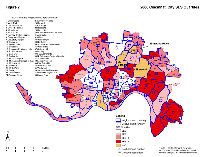
SES I: A High Problem Area The Social Area Described SES I is the area commonly thought of as the inner city. It is "worse off" on all the social indicators listed in Table 1a (see Appendix II for actual values). It is the white area in Figure 2. It includes all of Lower Price Hill, Linwood, North Fairmount-English Woods, Camp Washington, South Cumminsville-Millvale, Fay Apartments, Winton Hills, Over-the-Rhine, and tracts in East Price Hill, Westwood, South Fairmount, Northside, Roselawn, Avondale, Evanston, Walnut Hills, Mt. Auburn, and the West End. During the 1990s the East End moved up to SES II and, for the first time, single tracts in Westwood and Roselawn fell to SES I. Otherwise, the list of neighborhoods included in SES I has changed little since 1970. This area is 81 percent African American, and is known to have a large Appalachian population. There is also an emerging Hispanic presence. Six percent of the dwelling units are overcrowded. Only 32 percent are single family units but this is up from 22 percent in 1990. The unemployment rate is 18 percent (compared to 9% in 1970) and more than three-fourths of the workers are in blue collar or service occupations. Only 53 percent of the adults have a high school education. The median family income is $15,733. Fifty-three
percent of Cincinnati's families in SES I have incomes below the poverty level. The number of households in poverty in SES I declined from 16,072 to 5,045 between 1990 and 2000. This rate of decline (68%) was much greater than the population decline (17%). The rapid rate of decline in the family structure indicator (percent of children under 18 in two parent homes) slowed dramatically. Between 1970 and 1990 it had declined from 71.4 to 27.3. Between 1990 and 2000 it dropped to 24.4. Still, this means that only one child in four in SES I lives in a two parent home.
The number of households on public assistance declined from 11,382 to 5,045 during the decade. The percentage of the population who are first generation immigrants went up for the first time since 1970, from .9% in 1990 to 2.4% in 2000. This was nearly identical to the 1970 rate of 2.5%. This is probably due to an increase in the Hispanic population. The percentage of first generation immigrants increased in all four quartiles but only slightly. As in previous decades, foreign immigrants are now likely to live in the upper SES quartiles. Percentages of immigrants are down in all four quartiles since 1970.
In summary the news from SES I has positive features. Statistics for the 1990s show a reversal of the trend for the inner city to become poorer, more unemployed and more welfare dependent. Even the trend toward single parent families slowed down somewhat. The percentage of single family dwelling units has increased steadily since 1970 when it was only 15%. In 2000 it was 32%. (This compares to an average of 46% in the other quartiles). Trends in previous decades presumably reflected changes which have affected most American inner cities - white flight, deindustrialization, and the movement of jobs and tax base to the suburbs. The trend toward racial isolation continued in the 90s. If these positive trends continue and were not a temporary effect of the economic boom of the 90s, they offer real hope for improving the quality of life in the inner city. Progress on reducing crime, racial isolation, despair and drug addiction will also be necessary.
SES II: Second Stage Neighborhoods The second quartile, (shown in pink in Figure 2) is comprised of neighborhoods on the inner rim of the western plateau and the Mount Airy-Northside slopes, Winton Place, Corryville, Bond Hill, Linwood, Carthage, Evanston-East Walnut Hills, sections of the West End and Mt.Auburn, and clusters in Avondale, Fairview-Clifton Heights, and Madisonville. The census tracts in SES II are usually contiguous to SES I areas. Twenty three percent of the city's population live in this area. Fifty percent of the population is African American. (This is up from 43 percent in 1990 and is higher than the city wide percentage of African Americans (42.8%).
Shifts in CompositionOver the decades, the composition of this area has changed somewhat in terms of which neighborhoods it includes, but this change is not dramatic. During the 80s, tracts in the CBD, Madisonville, and Walnut Hills moved upward to a higher quartile and Linwood moved from SES I to SES II. These movements reflect redevelopment efforts in the CBD and Walnut Hills and population change in Linwood. There was also movement in the other direction. During the 80s six census tracts moved from SES II down to SES I. These tracts were in the East End, East Price Hill, Evanston, Avondale, West End and Fay Apartments (one each). During the 90s the area changed further. In West Price Hill, tract 98.02 moved down from SES III and tract 97.04 moved up to SES III. Evanston had one tract shift from SES III to SES II. In Avondale 2 tracts moved to SES II from SES I and two moved in the opposite direction. Linwood move to the top of SES I.
Social Indicator ChangesWith a median family income of only $30,190 most families in SES II struggle to make ends meet. In 1970 15 percent of the households had incomes below the poverty level. This rose to 18 percent in 1980, 24 percent in 1990, and 24 percent in 2000. In 1970 SES II was 41 percent African American. In 2000 this percentage was 50. In 1970 38 percent of Cincinnati's African Americans lived in SES II. This fell to 36 percent in 1980, 31 percent in 1990 and, in 2000, stood at 29 percent. The number of families decreased from 27,117 in 1970 to 17,811 in 2000. The family structure indicator was 73.5 in 1970 and fell to 34.7 in 2000. As with SES I, the area in 2000 was poorer, more African American and the two-parent family structure was disappearing.Table 2a Cincinnati Census Tracts and SES Quartiles
Although there is a great variation in income and education from home to home, the overall texture here is that of a working class neighborhood. The unemployment rate in Avondale was 12 percent in 2000. In East Price Hill it was 9 percent. In 2000 only 13 percent of the households have incomes below the poverty level. This compares to 24 percent in 1990. SES II can by no means be called a slum. School personnel and social workers do generally regard it as a high problem area, however. It is possible to regard much of SES II as the second stage settlement area for rural migrants from the South and from Appalachia, some of whom were displaced by the mechanization of agriculture and mining. Others came to the city to improve their living standards. Many of the present residents of SES II are believed to have moved there from the West End, Over-the-Rhine, Queensgate, Lower Price Hill and other "inner city" areas. This theory is supported by the dramatic population loss of Over-the-Rhine and the West End since 1960. From 1960 to 1980, the two neighborhoods lost over 35,000 people,
When urban renewal or code enforcement programs were launched in the Basin area, families who could not be (or did not wish to be) relocated in public housing projects moved on their own to the neighborhoods that were open to them. Many African Americans moved to Mount Auburn, Avondale, Walnut Hills, Evanston, and Madisonville. Appalachian Whites and other low-income families moved to East Price Hill, Fairview, Fairmount, and Northside. It is beyond the scope of this report to try to describe the process by which these population movements took place. Suffice it to say that there was already a trend of affluent whites moving out of the central city and that the influx of former Southern migrants was by no means the only force in operation. It is also important to note that David Varaday's 1974 report on residential mobility in the model neighborhoods states that SES I neighborhoods no longer serve as staging areas for migrants. The assumption that they did during the 1940 - 1970 period, to our knowledge, has not been refuted. The neighborhoods in SES II have their strengths. Many of the census tracts, for example, have less than seventeen percent of their population in poverty and an overcrowding indicator of less than four percent. They are neighborhoods where there are heavy concentrations of families struggling to rise above the poverty they once knew. As we noted above, this is an assumption based on our interpretation of recent Cincinnati history. The data of this report lend credence to the assumption. SES II is an area where most of the housing is multi-family; many of these homes have been converted from single-family use. (A considerable number, of course, are still owner occupied.) Nearly eight workers in ten are blue collar or service workers. Over 30 percent of the population above 25 years of age has less than a 12th grade education. In 1970 the fertility rates were dramatically lower in SES II than in SES I, yet the Family Structure Indicators were comparable for the two low SES areas. By 2000 the Family Structure Indicator for SES II had dropped to 34.7 (Table 2c). The 1974 study(1) predicted that reduction in family size accompanied by the strains of upward mobility would put stress on the family structure. In the 1986 study, this prediction seemed to have been borne out. Family breakup in SES I and SES II, as contrasted with the maintenance of two parent homes in SES III and IV, were among the more alarming discoveries of this study. By the 2000 census this picture had changed somewhat. The decline in the family structure indicator continued in SES II during the 1990s (Table 2c). But it declined even more in SES III - to the extent of greatly reducing the dramatic gap between the two quartiles in this indicator.
A report(2) done by the Ohio Bureau of Employment Services in 1984 on numbers and types of jobs available over the decade (1973-1983) indicate a decrease in manufacturing jobs of 79,400 or a 14.5% loss. During the same period service and non-manufacturing jobs increased by 62,500, increasing non-manufacturing jobs to 76%. Forty percent of this increase was in non-manufacturing jobs (i.e. fast foods, clerical, etc) which are minimum wage positions. Low income is a critical factor in family stability in the lower SES levels. Changes in family structure mean that there is an increased demand for family and youth services at a time when city resources are very limited, due to continued loss of tax base funds through loss of population and manufacturing jobs. Also, recent recessions have probably had a very adverse effect on family life in these areas.
Even though almost one in eight (13 percent) of the households in SES II were below the poverty level in 2000 (compared to 24 percent in 1990), community services are usually not as well developed in SES II areas as they are in SES I. Comprehensive community service centers are needed, but are not present in such areas as Carthage, Madisonville, Northside, Sedamsville, or Avondale. Such citywide services as the Department of Jobs and Family Services are trying to become more comprehensive in order to treat the whole range of individual and family problems. They remain centralized and bureaucratic. Individuals from SES II and further outlying areas may be physically and psychologically removed from contact with social services except in cases of extreme necessity. There may be a need for service centers within these neighborhoods(5).
It should be noted that thinking is shifting in some circles from a service provision model to an asset building model of community development. Xavier University and the Community Chest have funded The Community Building Institute to promote the new model. Therefore recommendations about providing more services should be reconsidered in that light. Asset based community redevelopment involves an emphasis on organizing neighborhood residents to utilize their personal, associational, and institutional assets to rebuild the economic and social fabric. As was noted in the 1974 study(3), SES II is characterized by low education levels, high rates of poverty, single parent homes, unemployment and inadequate family income. The 2000 census shows school dropout rates range from 11% in the East End and Bond Hill to 41% in Carthage. A community survey or review of crime statistics would probably show wide-scale delinquent or pre-delinquent behavior on the part of thousands of 16-25 year olds out of school and unemployed in this area. Neighborhood stabilization requires that schools, religious institutions and social agencies in the communities, backed by neighborhood organizations and area-wide resources, mobilize effective youth and family support services. This approach fits the asset building philosophy.
The low educational level and high incidence of poverty and single parent homes in SES II point to a need for special programs to strengthen the families and for special programs in the schools. Interviews with high school personnel in three different neighborhoods by Cincinnati Human Relations Commission staff indicate that many children enter junior high school with inadequate preparation in areas such as reading skills, and that the dropout rate is high. School personnel also mention a relatively high level of pre-delinquent behavior among youth, family conflicts, absence of parents (e.g. when both are working), and intergroup conflicts in and around school.
SES II families do not have ready access to services in their own neighborhoods. When a crisis (e.g., loss of job, marital problems, mental health problems) occurs they are often far from any source of intervention. So even though the social indicators are not as "bad" for SES II as for SES I, and no doubt many families here do have more private resources, there is a need to consider what additional public or private programs should be placed in these areas. As in the other social areas, the greatest need is for high wage jobs with good benefits.
SES III: Where Front Yards Begin The third quartile areas of Cincinnati, (shown in medium red on Figure 2) are comprised of Riverside-Sayler Park, Kennedy Heights, Sayler Park, University Heights, parts of Mt. Auburn, Westwood, West Price Hill, Oakley, Madisonville, Evanston, Walnut Hills, the CBD and three sections on the northern fringe of the city. If the city can be looked at as a geographic area in which successive waves of foreign or rural-to-urban migrants settle, develop ethnic communities and move on, then SES III could be called stage three.
Intuitively this makes some sense. The writer knows of one Irish family in which one generation was born in the East End, the next in Mount Adams and the third in West Price Hill. Some of the current generation live in Landen. Yet it would be an oversimplification to classify all of SES III thusly. Such an explanation might say a lot about the Germans and Irish in, for example, Price Hill and Northside, but it does not apply to University Heights-which houses successive generations of students and faculty of the University of Cincinnati; or to tract 19 in Walnut Hills, which has become a community of childless professionals. Tract 6 in the Central Business District once had low-income elderly pensioners as well as luxury apartment dwellers. SES III can be characterized as a series of middle class enclaves which border SES II or SES I areas on their central perimeter. About 43 percent of the residences are single family and many census tracts have large open space areas.
In SES III the population is 62 percent white and 38 percent African American. About five percent of the population in 1990 were first or second generation foreign born (ethnicity indicator). Median family income in 2000 was $47,500 and 66 percent of the workers were in blue collar or service jobs. On the other side of the coin, 2,029 SES III families are below the poverty line and almost 20 percent of the population over 25 years of age has less than a 12th grade education.
SES III is not a fortified middle-class sanctuary. In 1970, 14 of the 23 census tracts in this area were at least 90 percent white and eight were at least 99 percent white. By 2000, the area had become much more integrated and included integrated neighborhoods such as Corryville, East Price Hill, Winton Place, and Madisonville. Four neighborhoods that have at least one tract in SES III also have tracts in SES II and five (Evanston, Westwood, Northside, Mt. Auburn and Walnut Hills) also have one SES I tract. SES III is generally not separated from the lower SES areas by physical barriers such as expressways, parks or steep hillsides. The following quote from the Cincinnati Post and Times-Star (May 17, 1963) illustrates the point we are making about SES III.:
"Integration Potential"
David E. Todd, of New York, Chairman of the American Institute of Architect's housing policy task force, has a good word, for Cincinnati's urban integration progress. In an interview at the AIA's recent convention at San Francisco, he noted that "cities with a potential for integration are going to make it. Housing patterns are already set and where there is the capacity for well-to-do neighborhoods one or two blocks from a low income area that can be upgraded, there is a good chance of living side by side. "New York, Cincinnati, Philadelphia and Boston," Todd said, "are centers of city life for all income groups. In Detroit and Cleveland, I do have to wonder about the future of the downtown cities."
An examination of the base map (Figure 2) shows the accuracy of this analysis. Evanston, Walnut Hills, and Avondale, for example, are contiguous to higher income areas. As to the feasibility of upgrading various neighborhoods, the Urban Development Department has published an analysis entitled "From Urban Renewal to Community Development" which provides an analysis of the requirements to improve housing conditions in several neighborhoods. The City of Cincinnati has developed a housing strategy that would promote both integration and neighborhood stability.
The future of SES III is intimately tied to Cincinnati's success or failure in providing social services, good schools, and physical development programs for the contiguous low-income areas. Residents of SES III are generally aware of this connection and of their need to act positively to solve the problems that affect their own and nearby neighborhoods.
Note: For a discussion of the extent to which Cincinnati's integration potential has not been fully realized, see Chapter 4, Poverty, Race and Gender in Cincinnati.
SES IV The fourth quartile (indicated in darkest red on Figure 2) includes the neighborhoods of Mt. Lookout, Hyde Park, Oakley, Mt. Adams, California, Mt. Washington, Mount Lookout-Columbia Tusculum, Clifton, East Walnut Hills, North Avondale-Paddock Hills, and tracts in CBD, Pleasant Ridge, Mt.Airy, Westwood, West Price Hill, and Fairview-Clifton Heights.
SES IV includes scattered enclaves of relative affluence around the city. The largest sections are in the Hyde Park, Western Hills, Clifton, and Mount Washington-California areas. The emergence of the latter two neighborhoods to SES IV is new since 1990. All of East Walnut Hills is now in SES IV representing a change since 1990 as well. In several instances these areas are contiguous to SES I or II areas. Just as often, however, SES IV areas are "buffered" from lower SES areas by parks, hillsides, cemeteries and other open space areas. The SES IV area changed between 1970 and 1980 as follows. Mount Adams was added. Census tract boundary changes and/or demographic changes caused the northeastern part of Westwood to drop out. A redefined tract 84 in College Hill dropped down to SES III. Bond Hill, Hartwell, and part of Kennedy Heights dropped down to SES III and the newly defined Columbia-Tusculum area was added to SES IV, as a function of separating the neighborhood from Linwood which was in SES II in 1980. Changes in SES IV between 1980 and 1990 are as follows: tract 70 in Clifton, tract 53 in Oakley, tract 27 in Fairview-Clifton, and tract 106 in Sayler Park were added to SES IV from SES III. Tracts 81 and 84 in College Hill, tract 83 in Mt.Airy, tract 46.01 in Mt.Washington, tracts 62.01 and 110 in Roselawn and 109 in Westwood fell to SES III.
The 2000 Census saw further changes in the shape of SES IV. The major change was the addition of tracts in Mt. Washington and California. The other changes on the East Side were the addition of tract 42 in East Walnut Hills. Tract 7 in the CBD traded ranks with tract 6 and joined SES IV. (Downtown development officials need to look at why tract 6 declined). The far west side cluster of 6 SES IV tracts declined to only 5 in 2000. Tract 100.01 in Westwood dropped off the SES IV designation. Tract 88 fell to SES I. Westwood is now the only neighborhood in Cincinnati to have at least one tract in each of the four social areas.
Trends in SES IV since 1970 include the fact that today's SES IV has 76,271 fewer people. It is the only social area to continuously lose population. Today's SES IV is slightly more integrated than the counterpart area in 1970. The percentage of single family dwellings has hardly changed at 47 percent. Its immigrant population fell from 15.1 percent in 1970 to 4.8 percent in 2000. The percent of households below the poverty level fell to 3 percent. Almost two thousand households were on public assistance in 1990. This fell to 624 in 2000. Its elderly population fell to 17 percent, but was a higher proportion of elderly than any area except SES III. Its youth population (under 16) was 16 percent, which is lower than the other social areas. Its unemployment rate was 4 percent compared to 3 percent in 1970. Median family income was a hefty $65,500, six times that of 1970. SES I, by comparison, saw its median family income only double in the same time period. As clearly as any statistic can, this illustrates the growing gap between the haves and have-nots in Cincinnati. In 1970 the median family income ratio between SES I and SES IV was 2.23. In 2000 it was 4.2. This "inequality index" for Cincinnati almost doubled in three decades. At the metropolitan area level the gap was even wider. The median income in SES I is well below the poverty level. In SES IV the poverty rate for families ranges from 2 percent in Hyde Park to 12 percent in East Walnut Hills. The overall SES IV poverty rate was 3 percent (of households). The family structure indicator declined from 83.1 percent in 1970 to 73.9 percent in 2000. As with all the social areas, the occupation indicator increased dramatically until 1990 then dropped somewhat (table 2c). The education indicator decreased in all four social areas as well. By 2000, only 11.3 percent of SES IV's population over age 25 had less than a 12th grade education, down from 37.6 percent in 1970. Overcrowding has been reduced to a mere 0.9 percent.
Presumably most of the families in SES IV can provide for their housing, social service, and health needs through the use of private resources. Community issues in these areas center around preserving the existing character of their neighborhoods and improving the quality of public education. The issue of the quality of public schools (more than any other issue) brings SES IV people into dialogue with other neighborhoods. There are other problems which also cut across class lines. Drug abuse and mental health also pose problems which call for public intervention, as do law enforcement and the provision of utilities, parks, public transportation, and services for the elderly.
Patterns Of Concentration And Dispersal It has been noted that most of the buildings in SES I are multi-family and that many units are overcrowded. It is possible to be more specific and describe three different patterns of high density multi-family neighborhoods.
1. Public Housing: In 1970 Cincinnati had 7,184 rental public housing units occupied by some 20,000 individuals. Of these units, 5,821 were located in SES I. By definition, occupants of public housing are low or moderate-income families or elderly or disabled individuals. The concentration of public housing units in the West End and along the hillsides west of Mill Creek poses special problems for community residents and for those responsible for the planning and delivery of services in these areas.
One limitation of using overcrowding as a housing indicator is that it does not point to public housing as a "housing problems". Since public housing regulations do not permit "overcrowding," neighborhoods with large public housing projects are not always the most overcrowded even though sections of the tract may be very overcrowded. The five most overcrowded census tracts are in North Fairmount, Lower Price Hill, South Cumminsville, Winton Hills, and Madisonville.
2. High Density Private Housing and Section 8 Units Over-the-Rhine, Mount Auburn, and Lower Price Hill, for example, have areas of high density, low-income housing which is privately owned. The existence of large rent supplement rehabilitation projects in these neighborhoods should, however, receive special analysis. Also, in interpreting the data for a particular tract or neighborhood, it is important to note the existence of high rises and large apartment complexes.
3. Overcrowded Housing in a Dispersed Setting Columbia-East End and Riverside Sedamsville provide a different pattern that of a low-income population dispersed in narrow "string town" fashion along the river. This pattern poses special problems of transportation and communication which have been a perennial headache for planners and organizers in the East End.
The preceding discussion illustrates that for any specific planning purpose, knowing the SES typology is only a starting place toward neighborhood need definition. New strategies must be developed to link these neighborhoods, spread east and west along the Ohio River, with the rest of the city.
The Target Area Concept For Social Welfare ProgramsOne possible use of this report is in helping develop "target neighborhood" definitions for various social programs. SES I is considered a critical area for many programs on the basis of data presented in this report. However, this report needs to be supplemented with specific data from the area of intervention proposed. For example, health, mental health and crime and delinquency rates could be mapped out on a census tract basis. Since so many social indicators are highly correlated with social class, chances are that the highest rates would occur in SES I. However, it is possible that for some intervention programs census tract mapping would indicate at least partial inclusion of some of the other SES areas, especially SES II, which tend to be neglected. Certainly the data indicate that programs aimed at the problem of family stability or "broken homes" should not be concentrated in any one area of the city.
Problems Of The Target Area Approach
A. "Poor Services" One of the standard criticisms of the practice of creating special programs for people most in need is that such programs for the poor also turn out to be "poor services" and constantly suffer from lack of community support, funding and accountability. The other side of the dilemma is that when resources are scarce it seems only fitting to expend them where the need is greatest. The authors believe that the answer to this dilemma lies in providing certain essential services universally even if it means eliminating some of the present array of subsidies which, in fact, now favor the upper classes. But until there is a restructuring of national social policy it is important to be able to determine the areas of greatest need at the local level, and that is what this report does.
B. The Dispersed Poor Because some antipoverty strategies have used the 'target area" approach, to that degree the poor who live in more affluent neighborhoods are left to their own resources or to seek out private charitable organizations or city or county wide bureaucracies. In the absence of special outreach programs, the poor may never become aware that they are eligible for such services.
In 2000, there were 2,653 families with incomes below the formal poverty level living in the higher income areas (SES III and IV). Table 2b show that 51 percent of the poor live outside SES I. Use of the target area approach should not blind us to the needs of those who live outside the high-risk areas. The assumption that it is worse to be poor in all of the social disorder of a "hard core" neighborhood is true, but there can be real human need anywhere in the city.
Refining And Updating Target Areas
In the first edition of this report, the author called for expanding the target area for the programs of the Community Action Commission based on the report's findings. In the second edition, attention was called to the needs of Linwood, Walnut Hills, Evanston, Madisonville, Northside and Westwood because of declining indicators in those areas. Appendix II is especially useful for noting these trends by census tract and by neighborhood. Tables 2e, 2f, and 2g show the Cincinnati neightborhoods which experienced the greatest decline in the different decades.
The third edition (1996) pointed out the dramatic decline which Bond Hill, Avondale, Mt. Airy, Kennedy Heights, and Westwood had experienced since 1970. Between 1980 and 1990 the greatest declines were in Fay Apartments and Roselawn. Various agencies and citizen groups have used previous editions to justify the location of community centers and other programs. These include a senior center in Hyde Park and a recreation center in East Price Hill. Perhaps the most dramatic use of the Third Edition was by the civic leaders who successfully advocated for the establishment of an Empowerment Zone in Cincinnati. Hospitals, university programs, schools, and social agencies have used this report data extensively in proposals seeking funding for a great variety of health, education, and human service programs.
Table 2e Neighborhoods that declined 10 points or more between 1970 and 1980Neighborhood Decline Bond Hill -28.8 West Price Hill -23.2 Winton Hills -21.3 Kennedy Heights -20.6 Avondale -20.4 North Avondale-Paddock Hills -19.4 Over-the-Rhine -19.3 College Hill -16.6 South Cumminsville-Millvale -16.1 Hartwell -13.3 Evanston -13.0 Winton Place -11.2 Carthage -10.9 Walnut Hills -10.8
Table 2f-1Neighborhoods that Experienced the Greatest Decline 1970-1990
Table 2f-2Neighborhoods that Experienced the Greatest Decline 1980-1990
Table 2gNeighborhoods that Experienced the Greatest Decline 1990-2000
Between 1990 and 2000 twelve neighborhoods experienced SES decline of ten points or more (Table 2g). Four of these neighborhoods also show up in Table 2h as having experienced the greatest long term decline. These are Mt. Airy, North Avondale-Paddock Hills, Westwood, University Heights, and College Hill. At the top of the list for long term decline are Mt. Airy (44.4 points), Bond Hill (39.9), Westwood (26), and College Hill (25). Close behind are North Avondale-Paddock Hills (22.4), Roselawn (21.8), Avondale (21.8), and East Price Hill (18.8). We are pleased to report that Bond Hill, Avondale, Kennedy Heights, Mt. Washington, Fay Apartments, Northside, Roselawn, Winton Hills, East Price Hill and Pleasant Ridge can be taken off the critical list in that none of these neighborhoods, which have experienced long term decline, declined more than 10 points in the 1990-2000 period. Mt. Airy, Westwood, North Avondale-Paddock Hills, University Heights, and College Hill remain on the critical list as having experienced both long and recent decline. These are all second or third ring Cincinnati neighborhoods. Presumably inner city neighborhoods such as Over-the-Rhine, West End, and Lower Price Hill, already near the bottom of the SES scale, have nowhere to go but up. Many did experience gains on the SES Index during the decade. The results of community development efforts show up in dramatic gains in the East End. Table 2hNeighborhoods that Experienced the Greatest Decline 1970-2000
Note that the neighborhoods which experienced rapid decline on the SES index are distributed through all four social areas. Table 2e is based on neighborhood level data. Appendix III can be used to look at SES changes at the tract level. Block group data is also available on CD ROM for those who want to carry small area analysis even further.
Neighborhood leaders and planners of services should study these downward trends and, after determining whether they are artificial functions of boundary changes, plan appropriate service improvements or community renewal efforts.
From the data presented so far, the authors of this report conclude:
1. SES I is the highest priority area for health and social service planning. However, the majority of poverty households are dispersed throughout the other three social areas. Resources should be concentrated where the need is greatest but the dispersed poor should not be forgotten. 2. Demographic shifts and socioeconomic change can affect any section of the city. 3. Inequality has grown within the city as well as between the city and the suburbs. 4. Racial isolation has increased dramatically in SES I and somewhat in SES II. SES III and IV have become more racially integrated. SES I is moving closer to single race neighborhood status. 5. Between 1990 and 2000, there was a big reversal of the 1980-1990 trend of increased poverty levels. The poverty rate in SES I dropped from 53 percent to 36 percent. In the other three quartiles, the rate was cut in half (table 2b). The core inner city became more African American but less poor during the 1990s. Whether this was an effect of social policy or a booming economy is difficult to judge. It is likely an effect of both. It will be interesting to see what effect the recession of the early 2000s and social policy will have in the current decade. One might expect some repeat of the 1980s pattern unless the economy recovers dramatically or welfare reform accomplishes more than some people anticipate. 6. The welfare/poverty ratio (table 2b) altered radically in the 1990s. Only a fraction of households below the poverty level continued to receive public assistance in 2000. This will have long term effects. 7. The change in family structure in the two lower SES quartiles indicates a new inverse correlation between family structure and SES. In 1970, there was little difference between family structure in the high and low quartiles. In 2000, the traditional family structure survived only in the high SES areas. |
|||||||||||||||||||||||||||||||||||||||||||||||||||||||||||||||||||||||||||||||||||||||||||||||||||||||||||||||||||||||||||||||||||||||||||||||||||||||||||||||||||||||||||||||||||||||||||||||||||||||||||||||||||||||||||||||||||||||||||||||||||||||||||||||||||||||||||||||||||||||||||||||||||||||||||||||||||||||||||||||||||||||||||||||||||||||||||||||||||||||||||||||||||||||||||||||||||||||||||||||||||||||||||||||||||||||||||||||||||||||||||||||||||||||||||||||||||||||||||||||||||||||||||||||||||||||||||||||||||||||||||||||||||||||||||||||||||||||||||||||||||||||||||||||||||||||||||||||||||||||||||||||||||||||||||||||||||||||||||||||||||||||||||||||||||||||||||||||||||||||||||||||||||||||||||||||||||||||||||||||||||||||||||||||||||||||||||||||||||||||||||||||||||||||||||||||||||||||||||||||||||||||||||||||||||||||||||||||||||||||||||||||||||||||||||||||||||||||||||||||||||||||||||||||||||||||||||||||||||||||||||||||||||||||||||||||||||||||||||||||||||||||||||||||||||||||||||||||||||||
![[Image: Compass Rose]](/art/CompassRoseSmall.jpg)