|
|||
|
|
Chapter 4 POVERTY, RACE AND GENDER IN CINCINNATI
The concepts of race and ethnicity as used in the decennial census present some complex issues. For example, separate questions are asked about whether a respondent is black and whether a respondent is Hispanic. This means one can be enumerated as both black and Hispanic. Moreover, the 2000 census for the first time offered respondents the option of listing more than one race. This means, for instance, one could be multiracial (e.g., white and black) as well as Hispanic.
For the purposes of this report, we have defined as African American all non-Hispanic respondents to the 2000 census who listed themselves as being of one race, black. We have done this to maintain comparability with the previous editions of the Social Areas Report, and to avoid confounding ethnicity with race. This is not just a pragmatic decision, however. The social science literature indicates that within American society, multiracial people tend to adapt to the general white population to the extent they are able, while Spanish-speaking blacks do not readily assimilate into the resident African American population.
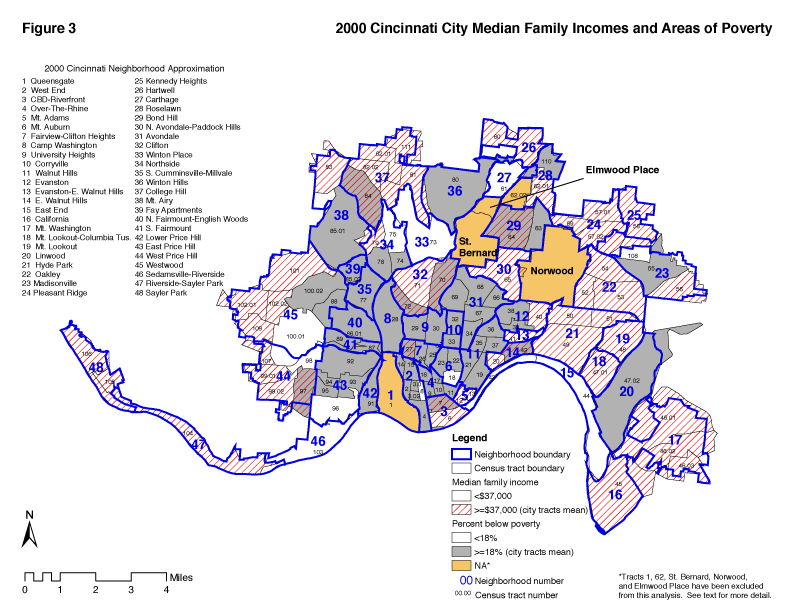
Poverty in Cincinnati In 2000, the median percent of Cincinnati families in each census tract with incomes below poverty level was 18 percent. The median income for Cincinnati families was $37,500. Figure 3 shows tracts that have poverty rates higher than 18 percent (gray areas) and incomes below the median incomes (striped areas). Most of these income indicators overlap. However, there are five areas on the map that are striped but not shaded. These five tracts have family incomes below the overall city median, but do not have high percentages of families below poverty. Two tracts (26 and 32) have high percentages of college students. The other three are blue collar Appalachian (61) and African American (41 and 63) sections. Table 4a reveals the numbers behind the map in figure 3.
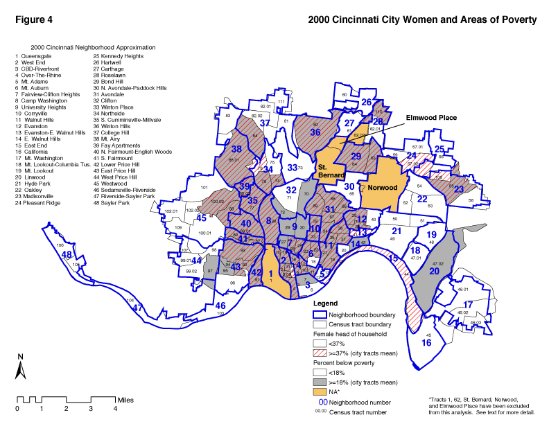
Women and Poverty Figure 4 illustrates the relationship between poverty and female headed households in Cincinnati census tracts. Note that the relationship between poverty and female-headed households is not consistent. Several predominantly Appalachian areas and the three tracts in the University of Cincinnati area have high poverty rates but not high percentages of female headed households. Other areas, some heavily African American, have high percentages of female headed households but not high rates of poverty. Excluding the atypical area around the University, figure 4 makes clear that even within the African American and Appalachian communities there are a variety of neighborhood patterns. Clearly, poverty and female headed households are not synonymous. Furthermore, there are several low income heavily white Appalachian areas in which traditional family structure is fairly intact. Table 4b provides the numbers and percentage of female headed households in poverty. Looking at all 48 neighborhoods, in 41 neighborhoods the majority of these families with incomes below poverty are female headed. In fact over 70 percent of the families in poverty are headed by a female. Table 4b reveals the majority of female headed families in poverty live in Over-The-Rhine, West End, Fay Apartments, College Hill, North Fairmount-English Woods, Winton Hills, Avondale, East Price Hill, and Westwood. Avondale and Westwood have the highest numbers.
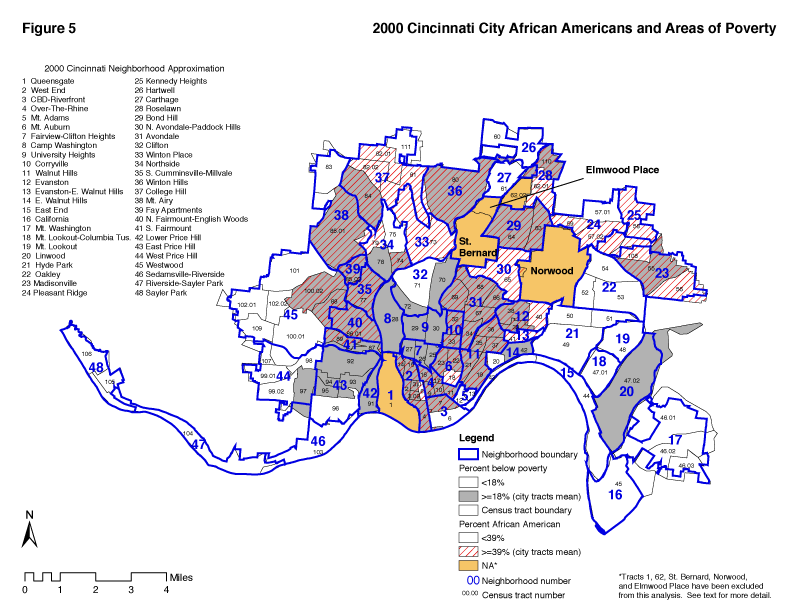
Poverty and Race Figure 5 illustrates the relationship between poverty and race. The two types of shading show that while the heart of Cincinnati's African American core area is also an area of high poverty, there are numerous tracts in which there are more than the median number of African Americans but poverty rates are not above average. Excluding the University area (tracts 27, 29, and 30) poor white areas are shown in the gray unstriped areas. These tracts are heavily Appalachian.
African American Middle Class Neighborhoods After viewing the 1990 census we were able to write that, One of the more dramatic and hopeful findings of this report is that the neighborhoods which have become home to the vast majority of Cincinnati's African American middle class have reversed a long trend of declining social indicators and are either stable or improving (Table 4c and Table 9).
Avondale, College Hill, Evanston, Kennedy Heights, Bond Hill, and Madisonville are beginning to stabilize after two decades of decline." Walnut Hills and Mt. Auburn have not only reversed their pattern of decline but, as of 1990, were improving. North Avondale - Paddock Hills, an SES IV neighborhood, not only reversed its pattern of decline, it also stabilized in terms of racial change (Table 4e).
Table 4a Cincinnati Neighborhoods' Median Family Incomes
Table 4a (continued) Cincinnati Neighborhoods' Median Family Incomes
This picture changed somewhat with the 2000 census. Avondale, Kennedy Heights, and Madisonville continued to improve on the SES scale (Table 9). Mt. Auburn and Evanston experienced a fractional decline that is not statistically significant. Bond Hill, College Hill, and North Avondale-Paddock Hills experienced decline of 8, 12 and 12 points respectively. A review of the tract level components of change in Appendix II revealed no obvious pattern. Declines in family structure and housing conditions seemed to be major components of change but there was great variety from tract to tract.
Working Class White AreasAmong the working class white Appalachian areas Camp Washington, the East End, Carthage, and Lower Price Hill saw improvements. East Price Hill, and South Fairmount continued a pattern of decline. Linwood, which had experienced positive change in the 1980s experienced a small decline in SES in the 1990s. Northside, which has affluent as well as working class areas, had a similar pattern. Sedamsville-Riverside declined insignificantly in the past two decades after some improvement in the 1970's.
Over the 30-year period, East Price Hill declined at the same rate as Avondale.
Working Class African American Areas Among working class African American neighborhoods only Over-the-Rhine, Winton Hills, Evanston, Walnut Hills, Avondale and Mt. Auburn saw decline in the SES scores relative to the rest of the city. None of these declines were of major proportions. Fay Apartments gained by one SES point after serious decline in the 1980s. Among neighborhoods with major public housing projects, Winton Hills declined by 5 points and the West End and South Cumminsville-Millvale actually improved in SES during the 1990s. North Fairmount-English Woods also improved in SES. Appendix III allows one to look at the changes in the census tracts within neighborhoods. What were the components of change? The Fay Apartments gained enough on the crowding and education indicators to offset losses on the other rankings. North Fairmount-English Woods declined on income and education but made gains on crowding and family structure. Improvements tended to also be multivariate. Tract 17 in Over-The-Rhine, for example, improved its rank in education, occupation, and crowding. South Cumminsville-Millvale saw improvements in its rank on overcrowding, family structure and occupation. Income and education indicators declined. These comparisons can be made for any census tract by using the Appendix II of the third edition with Appendix II of the current edition.
What Causes Decline What do the twelve neighborhoods which experienced the greatest decline have in common? They are all, except Winton Place and Corryville, in the two higher SES quartiles. Eight of the twelve experienced a net increase in the percentage of African Americans during the decade. The range in rate of increase was from 8 percent in the CBD to 83 percent in Fairview-Clifton Heights. Four neighborhoods experienced racial change in the opposite direction. Rapid racial change is clearly one aspect of change in socioeconomic status. Shifts in the economy can be another factor. Inmigration of residents of lower socioeconmic status or outmigration of more affluent residents can also affect social indicators for neighborhoods whether or not racial change is involved.
In the following sub sections, the last three US censuses will be used to analyze trends in Cincinnati as they affect various subgroups of the population, especially African Americans and Appalachians. The emphasis is on these two groups because they are large components of the population and, in many respects, the future of the city and metropolitan area are tied to their welfare.
Low Income African American Areas Table 4d shows the percentage of families below poverty for each neighborhood. It also reveals the percent and number that are white or African American. Table 4e just reveals the percentage of the neighborhood population that were African American from 1970-2000. The lower SES predominantly African American census tracts are as follows: Avondale (3 of 5 tracts), Mt. Auburn (1 of 3 tracts), South Cumminsville-Millvale, Over-The-Rhine (all 5 tracts), North Fairmount-English Woods, Walnut Hills (4 of 5 tracts), West End (4 of 7 tracts), Westwood (1 of 7 tracts) and Winton Hills. Again the 2000 census reveals some good news. In Avondale, the pattern of declining indicators leveled off in 1980 and little further decline has occurred. Neither has there been any progress except in tract 68 which rose to SES II status in the 1990s. The same is true of the West End. Tracts 2 and 8 experienced further decline. The other tracts improved. Tracts 14 and 15 became SES II. In Mt. Auburn, Walnut Hills and Winton Hills, the SES index declined somewhat but some census tracts experienced improvement (Appendix III).
In Over-the-Rhine, tract 9 experienced severe decline and now has an SES score of 3.0, the lowest of all Cincinnati area tracts. Tracts 10 and 17 improved. Tracts 11 and 16 each declined 5 points. Continued decline in 3 out of 5 tracts during a decade of economic boom confirms that the effect of a rising economy does not reach all segments of society. In North Fairmount-English Woods there was slight gain on the SES score.
Poverty rates were highest in Fay Apartments (67 percent), Winton Hills (65 percent), Over-the-Rhine (56 percent), West End (49 percent), South Cumminsville-Millvale (51 percent), North Fairmount-English Woods (51 Percent), Avondale (33 percent) and Walnut Hills (33 percent). These are all predominantly African American neighborhoods. The only white neighborhood with poverty of more than 50 percent was Lower Price Hill (56 percent). Table 4b Cincinnati Neighborhoods' Women and Poverty, 2000
Table 4b (continued) Cincinnati Neighborhoods' Women and Poverty, 2000
Table 4cNeighborhood Status, 2000
Table 4d Cincinnati Neighborhoods' Race Composition and Poverty, 2000
Table 4d (continued) Cincinnati Neighborhoods' Race Composition and Poverty, 2000
Table 4e Cincinnati Neighborhoods' African American Population, 1970-2000
Table 4e (continued) Cincinnati Neighborhoods' African American Population, 1970-2000
The poverty rate in Camp Washington, the second poorest white neighborhood, was 36 percent (Table 4b). (See chapter 9 for more neighborhood information).
African American poverty is concentrated in the SES I and SES II neighborhoods and in Westwood (650 families), College Hill (354 families) and Madisonville (261 families). There are 5,480 African American families in poverty concentrated in the SES I neighborhoods (Table 4d). This compares to 2,350 in SES II, 1,750 in SES III, and 520 in SES IV. The 2000 census reveals poverty rates for the four quartiles as follows: SES I, 45 percent; SES II, 24 percent; SES III, 14 percent; SES IV, 9 percent. During the 70s, poverty rates were relatively stable in SES II, III, and IV while continuing to increase rapidly in SES I (Table 2b). From 1980 to 1990 poverty rates increased by 9 points in SES I and by 3 points in SES IV. In the 1990s the poverty rate actually declined in SES I by 8 points. The poverty rates remained the same in SES II and SES III, and increased by 1 point in SES IV.
Low Income White Areas In addition to Lower Price Hill where 56 percent of the families were below poverty levels in 1990, Camp Washington (36 percent), and South Fairmount (28 percent) had poverty rates more than 25 percent. The highest concentrations of poor white families in sheer numbers are in West Price Hill (351), Westwood (430), East Price Hill (485), Northside (206), Mt. Washington (175), and Lower Price Hill (137). There are significant numbers of poor white families in North Fairmount-English Woods (41), Mt. Airy (81), Camp Washington (68), South Fairmount (75), Sedamsville-Riverside (54), Fairview-Clifton Heights (48), Oakley (31), and Hartwell (71). All of the predominantly African American neighborhoods, except Bond Hill and Mt. Auburn, have small numbers of poor white families. White poverty is in one sense very dispersed. The largest concentration however is on the West Side of Cincinnati. There are 1,395 poor white families in the area that includes South Fairmount, Lower Price Hill, and the top of the Western Plateau. This number is down from 2,223 in 1990. During the past decade, white poverty decreased in all of the neighborhoods mentioned above except Mt. Washington. The increase there is probably related to displacement from the East End which has lost much of its affordable housing stock. In all there are 2,189 fewer poor white families in the neighborhoods mentioned on this page than there were in 1990.
HispanicsThe number of Hispanics in Cincinnati increased from 2,386 in 1990 to 4,230 in 2000. This represents a 77.3% increase. Hispanics are dispersed throughout the 48 neighborhoods and do not constitute a major percentage in any one neighborhood. The largest concentrations are Westwood (334), East Price Hill (240), Mt. Airy (235), Oakley (223), and Hyde Park (199). Clifton has 193 persons of Hispanic origin and West Price Hill has 182. Lower Price Hill has 142. Avondale and College Hill each have 113, Fairview-Clifton Heights 137, Madisonville 100, Walnut Hills 141, West End 119, and Mt. Washington 123. The neighborhoods with the largest number of newcomer Hispanics from 1990 to 2000 were Mt. Airy (187), East Price Hill (127), Lower Price Hill (136), Oakley (139), Over-the-Rhine (111) and Westwood (107). Agencies concerned about newcomer Hispanics who may need services would want to include these neighborhoods. The growing Hispanic community is very complex in terms of socioeconomic status, national origin and other features. Most of the recent concern has been for newcomers who may not have good command of the English language and are subject to exploitation because of language and immigration status issues. In low-income community such as Over-the-Rhine and Lower Price Hill, there has been some intergroup tension, discrimination, and crime involving African Americans, Appalachians, and Hispanics. Various agencies have responded by providing interpreters and other services to newcomers. Hispanic data for this report is courtesy of Dev Seggar, Cincinnati City Planning, and includes only those persons who reported a single race.
SummaryIn 2000, there were 13,464 families below the poverty level in the city of Cincinnati. Three fourths of these were African American. This represents a change from 1990 when there were 16,945 poor families, 71% of whom were African American. In 1990, there were 5,052 poor white families. In 2000, there were 3,367. Cincinnati is losing poor white population. The immigration of low-income Hispanics from Mexico and Central America provides a new labor resource for Cincinnati. Like other population movements, it also creates interethnic conflicts in certain neighborhoods. The new immigration of Hispanics is having the effect of enriching Cincinnati's cultural diversity.
When we began this study in 1970, there were only nine neighborhoods with African American majorities. By 2000 there were 16. Ten of these were more than 75 percent African American. Does this mean that once a neighborhood reaches a certain level of African American population the "tipping point" is reached and the neighborhood becomes monoracial? There may be some truth in the tipping point theory but clearly there are exceptions. Several neighborhoods - South Cumminsville-Millvale, the West End, Evanston, Corryville, the East End, Mt. Auburn, Evanston-East Walnut Hills, Madisonville, East Walnut Hills, Mt. Adams, Hyde Park and Mt. Lookout all have a lower percentage of African Americans in 2000 than they did in 1970.
Eight of the 15 African American majority neighborhoods are in SES I, 3 are in SES II, 3 in SES III, and one is in SES IV (North Avondale-Paddock Hills). In 1970, five were in SES I, 3 in SES II, and one in SES III. These statistics suggest a degree of upward mobility on the one hand and a continuing pattern of residential segregation on the other. Another way of using Table 4e is to look at how many neighborhoods (24) were less than 10 percent African American in 1970 compared to 2000 (12). |
|||||||||||||||||||||||||||||||||||||||||||||||||||||||||||||||||||||||||||||||||||||||||||||||||||||||||||||||||||||||||||||||||||||||||||||||||||||||||||||||||||||||||||||||||||||||||||||||||||||||||||||||||||||||||||||||||||||||||||||||||||||||||||||||||||||||||||||||||||||||||||||||||||||||||||||||||||||||||||||||||||||||||||||||||||||||||||||||||||||||||||||||||||||||||||||||||||||||||||||||||||||||||||||||||||||||||||||||||||||||||||||||||||||||||||||||||||||||||||||||||||||||||||||||||||||||||||||||||||||||||||||||||||||||||||||||||||||||||||||||||||||||||||||||||||||||||||||||||||||||||||||||||||||||||||||||||||||||||||||||||||||||||||||||||||||||||||||||||||||||||||||||||||||||||||||||||||||||||||||||||||||||||||||||||||||||||||||||||||||||||||||||||||||||||||||||||||||||||||||||||||||||||||||||||||||||||||||||||||||||||||||||||||||||||||||||||||||||||||||||||||||||||||||||||||||||||||||||||||||||||||||||||||||||||||||||||||||||||||||||||||||||||||||||||||||||||||||||||||||
![[Image: Compass Rose]](/art/CompassRoseSmall.jpg)