|
|||
|
|
Chapter 8UNEMPLOYMENT AND JOBLESSNESS
One of the limitations of this report is that the data are now four years old. Some of the data were not available until the fall of 2003, however, because the different census "counts" are published at staged intervals. The data are still useful if one assumes that even though the precise statistics change, the relative position of various types of neighborhoods do not change dramatically unless there is some kind of national or community - wide change in economics or location of a major urban renewal program. Some of the changes brought about by welfare reform were captured in the 2000 census. The effects of the 2000 recession are not.
Definitions The Census Bureau considers a person "employed" if he or she had a job or worked even part time at a family farm or business during the week the census was taken. A person is considered "unemployed" if he or she (a civilian 16 years or older) did not have a job but had looked for a job within the past four weeks and was available for work. A frequent criticism of this definition of "unemployment" is that it may exclude the discouraged worker, the person who has simply quit actively looking for work due to past failures or current labor market conditions. The employed and the unemployed together comprise the "civilian labor force." The unemployment rate is expressed as a percent of the civilian labor force. Those classified as "not in the civilian labor force" include inmates of institutions, students, others under 65, and others over 65. Presumably it is in the category "others under 65 not in the civilian labor force" where we would find discouraged workers. A combination of those unemployed and those "under 65 not in the civilian labor force" are classified as jobless in Table 8a. And finally, "under- employed" or "sub employed" are terms used to designate those persons who may be working but who do not earn enough to support themselves and/or their families.
In 2000, less than half of Cincinnati's 48 neighborhoods had equal to or less than the city wide unemployment rate of 9.0 percent. In 1970 there was about the same number below the city wide average of 4.7 percent unemployed. In 2000 there were six communities with unemployment rates double the city average compared to eleven in 1990, seven in 1980 and five in 1970. African American and Appalachian neighborhoods made up all those with higher unemployment.
Only five African American neighborhoods and four Appalachian enclaves had less than the city mean for unemployment. A high unemployment rate correlates positively with a high rate of high school dropouts and low SES ranks. The implications of this relationship can be long-term dependency on social welfare programs, little or no upward mobility, unstable family situations and an ever widening gap in the resources of communities with high unemployment and those with high employment. Community resources are no doubt enhanced by mutual aid and the informal economy. Table 8a illustrates that not everyone went to work after welfare reform was implemented though the full results are not reflected in the 2000 census.
Even though the unemployment rate nearly doubled in the decade 1970 - 1980 and dropped only slightly in 1990, the working climate of Cincinnati is worse than the statistics portray. Many of the jobs that are available now are minimum wage service positions with little or no hope of advancement. Many of the working poor are underemployed and are living below the poverty level.
The implications of this trend toward more low paying service positions is that the economic situation becomes more and more critical and destabilizes families; hence poverty becomes more profound. Competition for jobs will become even more keen. A growing number of jobless (discouraged workers) can be expected. In the chapter with recommendations, alternatives to high unemployment and joblessness will be addressed.
The above prediction, penned in 1990, was not fully borne out by the 2000 census. Unemployment rates went up in only three SES I neighborhoods between 1990 and 2000. The rate remained the same in one and hovered just below 1990 levels in 2000 in five more. However, the city rate was high and the economy was in full boom in 1999 when the census survey was done.
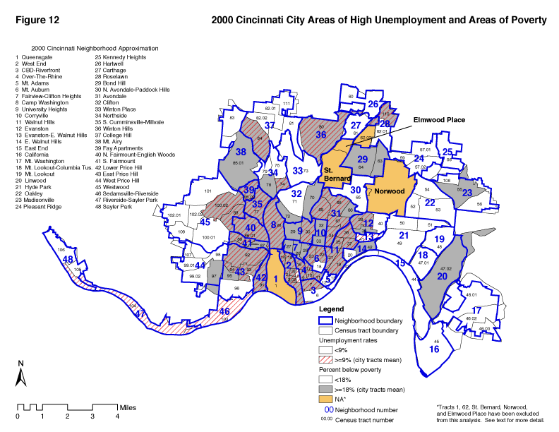
Figure 12 shows areas with a 2000 unemployment rate overlaid on the poverty area map. There is a high degree of correspondence between the two areas as one would expect. The apparent anomalies are areas that show high poverty rates but not high unemployment rates and are easy enough to explain. Linwoood, for example, has an unemployment rate of 8%, just under the average. At least three neighborhoods in SES III and IV have high unemployment rates. No explanation is readily available.
Table 8a presents both the unemployment rates and jobless rates for each neighborhood. Unemployment rates in SES I range from 9 percent in Linwood to 29 percent in Fay Apartments. Jobless rates are highest in Camp Washington, Over-The-Rhine, Fay Apartments, Winton Hills, North Fairmount-English Woods, South Cumminsvale-Millvale and West End. Evanston and Mt. Auburn have the highest unemployment and jobless rates in SES II.
Table 8b shows the trends. There is a rather complex pattern of increases and decreases in inner city unemployment. While the unemployment rate went up 58 percent in Fay Apartments and 33 percent in South Fairmount, it actually decreased in five SES I areas. This pattern was similar in SES II with more neighborhoods experiencing decreases in unemployment rates than increases. Between 1990 and 2000 unemployment increased the most in Mt. Airy (42%) and Camp Washington (33%). Compared to unemployment rates, changes in jobless rates were less in both quartiles. Joblessness increased in 11 neighborhoods during the two decades. North Fairmount-English Woods, Camp Washington, and Over-the-Rhine suffered the greatest increases in joblessness (1980-2000). Decreased in unemployment rates often reflect the "discouraged worker syndrome" - people dropping out of the labor force. Hence, the jobless rate acts as an important supplement to the unemployment rate. Discouraged workers going on disability also keep unemployment rates artificially low.
In SES III and SES IV (Tables 8a and 8b) unemployment ranged from 2 percent in the three top neighborhoods to 16 percent in the CBD-Riverfront. In these neighborhoods the biggest increases in unemployment (1980-2000) were in Riverside-Sayler Park (136 percent) and Roselawn (109%). Upper SES areas benefited more from the economic recovery of the late 80's than the lower SES areas according to the statistics in Table 8b. They may have also benefited more from the boom of the 1990s.
|
|||||||||||||||||||||||||||||||||||||||||||||||||||||||||||||||||||||||||||||||||||||||||||||||||||||||||||||||||||||||||||||||||||||||||||||||||||||||||||||||||||||||||||||||||||||||||||||||||||||||||||||||||||||||||||||||||||||||||||||||||||||||||||||||||||||||||||||||||||||||||||||||||||||||||||||||||||||||||||||||||||||||||||||||||||||||||||||||||||||||||||||||||||||||||||||||||||||||||||||||||||||||||||||||||||||||||||||||||||||||||||||||||||||||||||||||||||||||||||||||||||||||||||||||||||||||||||||||||||||||||||||||||||||||||||||||||||||||||||||||||||||||||||||||||||||||||||||||||||||||||||||||||||||||||||||||||||||||||||||||||||||||||||||||||||||||||||||||||||||||||||||||||||||||||||||||||||||||||||||||||||||||||||||||||||||||||||||||||||||||||||||||||||||||||||||||||||||||||||||||||||||||||||||||||||||||||||||||||||||||||||||||||||||||||||||||||||||||||||||||||||||||||||||||||||||||||||||||||||||||||||||||||||||||||||||||||||||||||||||||||||||||||||||||||||||||||||||||||||||
![[Image: Compass Rose]](/art/CompassRoseSmall.jpg)